
Hatteras Island
The Outer Banks stretch along North Carolina’s coast like a necklace jeweled with lighthouses. A once-wild place that’s played a part in our nation’s history from the first English child born in the New World to the first flight taken by humankind to the first foothold of the U.S. Life Saving Service (now called the Coast Guard) in North Carolina, much of the wildness has been tamed. Many visitors think of the northern villages – from Nags Head to Duck – and the rows of beach houses, hotels and restaurants as The Outer Banks, forgetting the untamed nature and the yesteryear charm of Hatteras Island. Simply put, Hatteras Island is the only place where you can experience a bit of what life was like on the Outer Banks before the world found us.
Seven villages, two lighthouses, and one National Seashore make up Hatteras Island. In every village and town – Rodanthe, Waves, Salvo, Avon, Buxton, Frisco, and Hatteras Village – the past rubs up against the present and in waters where wooden fishing boats once hauled in the day’s catch in a hand-woven net, sleek fishing boats carry charters out to the Gulf Stream and modern trawlers haul in a ton of shrimp at a time; the Bodie Island and Cape Hatteras Lighthouses run on electricity, not whale oil, but their lights shine out across the hidden dangers of Diamond Shoals and Oregon Inlet all the same; and everywhere you look it’s unlike any other place in the world.
Jump To: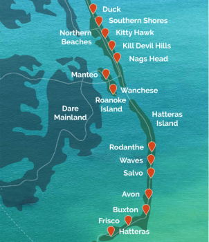
Hatteras Island is unlike anywhere else thanks in part to the Cape Hatteras National Seashore, the first of its kind. Established in 1937 to preserve the integrity of this thin barrier island, the National Seashore limited growth, virtually freezing the villages in time and limiting their ability to grow into the wild woods and dunes of Hatteras Island, instead these small, tight-knit communities remained relatively isolated and their cultures, which developed over more than a century of life on the Banks, distinct. Within Cape Hatteras National Seashore you’ll find all seven of the island’s villages, but also woods, dunes, marsh, and beaches so pristine as to border on perfect.
That’s a secret many Hatteras Islanders kept to themselves for years. Families here worked the water for a living, hauling nets full of fish to shore, gathering oysters and clams by the barrel, risking their lives to save the lives of those shipwrecked on the sandbars and shoals just offshore, and for generations their lives remained relatively unchanged. They saw each of the Bodie Island Lighthouses rise from the sand, shine their lights into the sea swept night, and the dim as their replacement rose even higher and more sturdily built. They saw the Hatteras Lighthouse tower above the trees, withstand grapeshot and musket ball in the Civil War, and, much later, in 1999, move inland, away from the encroaching sea.
Hatteras Island has seen shipwrecks (so many that this part of the coast is called The Graveyard of The Atlantic), pirates (including Blackbeard), the ravages of the Civil War and later the German U-Boats of World War II. Storms. Its villages have gone by a dozen names. Through it all, the island and its people have persisted and today Hatteras Island is a haven for those seeking the unspoiled nature of the Outer Banks, for surfers looking for that perfect break, for anglers looking to avenge the one that got away, for families building generations of memories in a cherished place, and for the locals who love this island like no other.
Hatteras Island Recreation
There’s no shortage of things to do on Hatteras Island, but by that same token, you’ll be hard pressed to find the arcades and mini golf and go karts and boardwalks of other beach towns. Instead, things are simpler here. Folks come to climb the lighthouses or to paint them or find the perfect angle for a jaw-dropping photograph. Anglers come for the charter fishing fleets at Oregon Inlet and in Hatteras Village, and with the Gulf Stream only 15 miles offshore, they come for sportfish within easy reach. Anglers also head to the inshore waters of the Pamlico Sound and the marshes and creeks there. And they come for the beach, to drive their 4x4s onto the sand and find an isolated spot where they can surf cast and watch pelicans dive for their dinner. Visitors come to slow down, to take a breath, to be the only ones on the beach and to reconnect with their families and friends and themselves.
Horseback riding, wildlife watching – and even waterfowl hunting, in season, of course – surfing some of the most consistent breaks on the East Coast, these things call visitors to the campgrounds and oceanfront homes and mom and pop motels. On the Pamlico Sound you’ll see kayakers and standup paddleboarders, even kiteboarders being pulled along by their giant parachute-like kites. On the wooden fishing piers in Rodanthe and Avon you’ll find locals – long-time transplants, transplants who have recently arrived, and the fourth or fifth or sixth generation Hatteras Islanders – fishing alongside visitors.
Hatteras Island is a wild place, a perfect place, a place like no other. It’s the Outer Banks as they used to be. It’s full of charm and hospitality. It’s waiting to be discovered by you, to show you the whole history of the Outer Banks. Hatteras Island is waiting to give you an experience that’ll have you coming back year after year after year and counting the days until you’re standing in the shadow of the Cape Hatteras Lighthouse again. Hatteras is here, it always has been; now’s your time to discover what it has in store for you.
Outer Banks National Scenic Byway
You’ll notice roadside signs beginning near the entrance to Cape Hatteras National Seashore bringing to your attention that you’re now on the Outer Banks Scenic Byway. Both the National Seashore and National Byway begin at the same spot, but they end in different places. Whereas Cape Hatteras National Seashore is 70 miles long, the Outer Banks Scenic Byway runs the length of Highway 12 in the National Seashore and continues further via ferry to its southern terminus in Carteret County to our much farther south. The Outer Banks Scenic Byway is one of three national scenic byways in North Carolina, recognized for its cultural contributions to our state heritage and identity alongside the unencumbered natural beauty and pristine setting. Places like Chicamacomico US Life-saving Station and Graveyard of the Atlantic Museum help expand the story of the Outer Banks Scenic Byway along with a growing number of wayfinding signs and roadside venues noted for their historic and cultural values, from simple vistas and overlooks to signs noting historic events in the American story.
Bodie Island Lighthouse
The Cape Hatteras National Seashore begins at Whalebone Junction and what’s known as Bodie (pronounced “body”) Island. Yes, an inlet once separated Bodie Island from Nags Head and the northern Outer Banks, but it’s since filled in. Still, Bodie Island, with its protected beaches, maritime woods, and extensive marsh complex sets the stage for what’s to come on Hatteras Island, including the Bodie Island Lighthouse, which together with Cape Hatteras Lighthouse and Ocracoke Lighthouse make three such guardians in the Cape Hatteras National Seashore.
As you head south from Whalebone Junction, it doesn’t take long for the black crown of the Bodie Island Lighthouse to appear above the tops of the pines. Standing 156’ high, the Bodie Island Lighthouse towers over the island, casting its warning light far out to sea. Upon first glance you’ll find the Bodie Island Lighthouse irresistibly photogenic. Its black and white striped paint job – distinct paint jobs like this are known as “daymarks” and allow sailors to tell one lighthouse from another; lighthouses also have a unique “nightmark” in the pattern of their blinking light – makes it a lovely sight from any angle, but there’s more to do here than just snap a few pics to share with your family and friends. The lighthouse keeper’s cottage and other outbuildings have been turned into museums where you’ll find stories and historic photos that help bring this place to life. You’ll also find tickets to climb the Bodie Island Lighthouse sold here.
You can climb Bodie Island Lighthouse from the third Friday in April through Columbus Day in early October. Tickets are $10 for adults and $5 for seniors (over 62) and kids age 11 and under. Climbs are self-guided and run from 9am to 4:30pm, when the final group of the day heads up the spiral stairs to the top. Only eight visitors can go up at a time, so if you want the view from the top – and you do – get there on the early side as climbing the nearly 200 steps to the viewing platform will take a little while.
From the top, the view of the Atlantic Ocean, Pamlico Sound, and the thin ribbons of Bodie and Hatteras Islands, will render you speechless for a moment before you notice the complex of marshland and creeks buffering the island from Pamlico Sound. Anglers and photographers take note: a trail on the western side of the parking area leads you to several places where you can cast a line or find a seldom-seen angle on shooting the Bodie Island Lighthouse, but the hiking can be a little tough, so you’ll want to wear something more than sneakers and you’ll want to avoid wearing flip flops all together.
Built in 1872, this is the third Bodie Island Lighthouse to guard this stretch of coast. The first, built in 1847, stood a few miles south, just on the other side of the Oregon Inlet. Built on shifting sands with a bad foundation, after 2 years, the lighthouse had a distinct lean, and by 1859 it was abandoned and replaced. The second Bodie Light, which came online in 1858, also stood south of Oregon Inlet, and it lasted until the early days of the Civil War when retreating Confederate troops blew it up to hinder Union naval forces in the area. Construction on our Bodie Island Lighthouse – that black and white striped beauty we know – began in 1871 and by 1872 it was completed and shone its beacon for the first time.
Pea Island National Wildlife Refuge
Once you cross over Oregon Inlet by way of the Marc Basnight Bridge coming south from Nags Head and the entrance to Cape Hatteras National Seashore, you’ll see a big sign saying Pea Island National Wildlife Refuge right off the bat. Don’t worry, you didn’t take a wrong turn, you’re still on Hatteras Island. Pea Island National Wildlife Refuge is a 13 mile sanctuary for migratory birds, sea turtles and all sorts of creatures worth pausing to observe. The park is a favorite among birdwatchers in America who make special trips just to see various bird species when they’re in the area, but you don’t have to be a dedicated hobbyist to enjoy the view. In fact, chances are that you’ll see something incredible if you come back and come often. Across the 5,834 acres of beaches, soundfront shoreline and bird ponds, a total of 365 birds have been officially spotted by park staff and visitors, along with 25 species of mammals, 24 species of reptiles, and 5 types of amphibians such as frogs and salamanders. That’s a lot! There are walking trails with observation platforms at the end to get a better view of the bird colonies in action, or you can just pull over on the side of the road if something catches your eye. Right across the street from the Pea Island Visitor Center, you might get some great seashells on the beach. If you notice what appears to be a stove pipe sticking out of the water about 100 yards in the water, it’s actually the wreck of the Oriental. The Oriental Steamer was a 210' federal tanker that ran aground about three miles south of Oregon Inlet on May 16, 1862 during the American Civil War. What you’re seeing popping up from the water is what remains of its steam engine.
Cape Hatteras Lighthouse
Perched on the point of Hatteras Island, the Cape Hatteras Lighthouse – the tallest brick lighthouse in the United States – has stood as a symbol of the Outer Banks for more than 150 years. The black and white spiral design (a unique pattern called a “daymark”) gives this lighthouse a memorable look for sailors, locals, and visitors, as if its towering height – 198’ – isn’t distinctive enough.
The Cape Hatteras Lighthouse has quite a story, but its best told with a view from the top where you can look out over the waves; the sunken sandbars of Diamond Shoals; and the shore stretching out of sight to the north, then turning the corner and disappearing to the southwest. Like the Bodie Island Lighthouse, this is not the first Cape Hatteras Light to stand on the Outer Banks, it’s the second. The first, built in 1803, was only 90’ tall and used a whale-oil lantern to light the way. Too short and shining a weak light, the lighthouse was modified and 60’ was added to the top where a more powerful lens was installed to help magnify the lighthouse’s guiding beam; by 1853 the “new” lighthouse was up and running. But the wind, waves, and Civil War left the tower damaged and in ill repair, and by 1870 a brand new replacement lighthouse – the one we see here today – was built.
That’s not the whole story of the Cape Hatteras Lighthouse. From the top, if you look north you can find the place where this lighthouse originally stood (can’t find it? Ask the Park Ranger stationed at the top to point it out). Rising ocean levels and active storm seasons eroded the beach, moving the ocean closer to the lighthouse with every year and by 1935, the Hatteras Light had been decommissioned and replaced with a skeletal steel tower known as the Buxton Light. But this is a barrier island and just as sand is eroded away, more sand is deposited on shore, and by 1950, the beach was safe and established and the Cape Hatteras Lighthouse was brought back into service. From the 1960s through the 1980s, the beach eroded again, the ocean was dangerously close to the lighthouse and a decision was made: to move – yes, move – the lighthouse.
Moving the Cape Hatteras Lighthouse – all 1.25 million bricks that make up the 198’ tower, plus the historic lighthouse keeper’s cottages and outbuildings – was no easy feat. Over a 23-day span in the summer of 1999, the lighthouse was lifted from its foundation and moved 2,900 feet to the place where it stands today. Climbing Cape Hatteras Lighthouse has been a rite of passage for generations, and the 257 steps to the top deposit climbers on a catwalk where the view is nothing short of jaw dropping. You can make a self-guided climb from the third Friday in April through Columbus Day in early October. Tickets are $8 for adults and $4 for seniors age 62 and up and kids age 11 and under.
In some ways Cape Hatteras National Seashore transformed Hatteras Island into a playground shaped by Mother Nature. Beachcombing for driftwood, the elusive Scotch Bonnet shell, or even debris washed up from some undersea wreck; birdwatching around the waterfowl impoundment ponds; surfing, kayaking, or kiteboarding; fishing; taking your 4x4 for a spin on the beach; climbing the Bodie Island and Cape Hatteras Lighthouses; and lazing the day away only steps from the Atlantic Ocean are just some of the things you can get into on Hatteras Island. You can explore the Pamlico Sound from atop a standup paddleboard. You can build a fire on the beach (you’ll need a permit and to know a few rules, but they’re easy to follow). You can ride a horse through the surf. But most of all, you can rest, relax, unwind, and find the ideal getaway you’ve been looking for right here on the Outer Banks.
Beach Access
Whether you’re on Hatteras Island to fish, surf, work on your tan, or collect a bucket full of shells, the odds are good you’re going to the beach. There are beach access points in every village on Hatteras Island and at numerous points throughout Cape Hatteras National Seashore, although not all of them are open to the public. Many beach houses have private access – boarded walkways or rustic paths through the dunes – for an individual home, to serve a cul-de-sac, or to provide access to every resident and renter on a particular street or neighborhood. That said, beach accesses for visitors abounds. Across Highway 12 from the Bodie Island Lighthouse, the Coquina Beach Day Use Area has abundant parking, showers, changing rooms, and restrooms. The Salvo Day Use Area has a collection of picnic tables on the edge of Pamlico Sound and a path across the dunes to the beach. And at the Cape Hatteras Lighthouse – where there are a pair of campgrounds within shouting distance of the waves – there are many ways to get to the water.
There are more beach accesses to be had, but only three within the National Seashore have lifeguards. From Memorial Day weekend through Labor Day, lifeguards watch over Coquina Beach (on Bodie Island), Cape Hatteras Lighthouse Beach (adjacent to the lighthouse), and Frisco Beach (just south of the village). Lifeguards are there daily from 9am-5pm. The remaining beach accesses are unguarded, so be sure to observe the appropriate precautions (available here << https://www.nps.gov/caha/planyourvisit/swimming-safely.htm>>) before you go for a swim.
Beach Access points are marked by brown signage with white letters, and many are numbered (these share an access point with ORV areas) on Hatteras Island Include:
- 2: Coquina Beach Day Use Area. Seasonal lifeguard. Bathhouse, ample parking. A boarded walkway leads to the beach.
- Oregon Inlet Campground: open to registered campers only.
- 4: on Bodie Island at the foot of the Bonner Bridge. Small parking area. Walk to the beach along the ORV entrance.
- Rodanthe Pier: pay for parking in the pier house.
- 23: small parking area, beach access via ORV entrance. Seasonal (route open October 15-April 14)
- 25: boardwalk leads to beach.
- 27: boardwalk leads to beach.
- 30: access via ORV entrance
- 32: small parking area; beach accessed via ORV entrance.
- 34: beach access via ORV entrance.
- Avon Fishing Pier: pay for parking in the pier. Public showers available.
- 38: small parking area and dune walkover access to beach.
- 58/Haulover Day Use Area: sound-side access, showers, restrooms, picnic tables, and parking; dune walkover to beach.
- 59: sound-side parking, dune walkover to beach.
- 43: Old Lighthouse Beach at Cape Hatteras Lighthouse. Seasonal lifeguard. Showers, restrooms; visitors center nearby. Direct access to beach.
- 44: near Cape Point Campground, access via ORV entrance.
- 48: access via the Inside Road between Frisco and Cape Point campgrounds. Beach access via ORV entrance.
- 49: near Frisco Campground. Parking not adjacent. Beach access via ORV entrance.
- Frisco Beach Parking Area: in Frisco .7 miles from turnoff to Frisco/Billy Mitchell Airport and Frisco Native American and Natural History Center. Abundant paved parking, showers, changing facilities, restrooms. Direct beach access. Seasonal Lifeguard.
- Frisco Day Use Area: immediately south of the Frisco town line. Showers and restrooms available. Boarded walkway to beach.
- Sandy Bay Parking Area: sound-side access. Launch site for kiteboarders, kayakers and paddleboarders. Beach access across Highway 12.
- 55: In Hatteras Village adjacent to the Graveyard of the Atlantic Museum. No facilities. Walkway to beach.
Hunting
Waterfowl hunting is permitted on Cape Hatteras National Seashore, but only in designated areas on Bodie Island. There the National Parks Service maintains 20 hunting blinds including the ABA-accessible Bodie Island Marsh Blind, though conditions and availability of blinds vary, and hunters should be prepared to construct a temporary blind if necessary. TO hunt, you’ll need a valid North Carolina hunting license with waterfowl privileges, a Federal Harvest Program (HIP) certification, and a Ducks Unlimited stamp. Hunters must register at the Whalebone Junction Information Station at 4:30am to be assigned a hunt area. For full hunting procedures and regulations – including maximum party size, firearm and ammunition limitations, rules for retriever dogs, and hunting area entrance/exit procedures, are available and regularly updated on the Cape Hatteras National Seashore website, here.
Off Road Vehicle Use on Hatteras Island
On Hatteras Island and throughout Cape Hatteras National Seashore, spotting a truck or SUV on the beach is a common sight. Anglers, surfers, thrill seekers and the most intrepid of beachgoers take advantage of the National Seashore’s ORV (Off Road Vehicle) policies and head out onto the sand. Certain sections of the shore are open to permitted ORVs, some year-round, others seasonally, but both require a permit from the National Parks Service before you lower your tire pressure and hit the beach.
To obtain an ORV permit, you’ll need to pay the fee - $50 for a 10-day permit, $120 for a 1-year permit – and fill out the paperwork. You can get our ORV permit at home by applying at www.recreation.gov and printing the registration and windshield tag, or you can apply and pay your fee in-person at either the Bodie Island Lighthouse Visitor Center or the Cape Hatteras Lighthouse Visitor Center.
Qualifying for an ORV permit is easy. All you need is a registered, licensed, insured vehicle of no more than two axles and approved, road-legal tires; you’ll also need a low-pressure tire gauge, jack, and jack support board. Full procedures, requirements and links to register are available here.
A little know-how on driving in deep, soft sand will help you out too (and hopefully keep you from calling a tow truck).
- Lower tire pressure to around 20 psi. This helps your tires grip the sand more easily, giving you better traction in the deep, loose sand.
- A 4x4 is better than AWD (all-wheel drive) or two-wheel drive.
- Stay in the established tire tracks whenever possible.
- Follow the same rules as the paved road: stay to the right, pass only when necessary, don’t veer “off road.”
- Stay off the dunes and out of marked areas.
- Stay out of the water. Saltwater is quite corrosive and bad for your vehicle.
- Reinflate your tires as soon as possible – this means in the parking area (if you have a compressor) or at the first gas station you see.
- Wash your vehicle, especially the underside, as soon as you can, again, saltwater is quite corrosive
ORV access points are marked by brown signs with white numbers and letters, and each one is numbered for easy reference. There are ORV access points on the ocean- and sound-side of Highway 12, though the ocean-side accesses have larger, more visible signs. Access ramps are open from 7am-9pm unless otherwise noted. Year-round access is available at:
- 2: Coquina Beach Day Use Area on Bodie Island. Open 6am May 1-July 31; open 6:30am August 1- September 30.
- 4: Oregon Inlet. Open 6am May 1-July 31; open 6:30am August 1- September 30. Year-round access traveling north (toward Coquina Beach) only; travel south toward Oregon Inlet open seasonally.
- 25: approximately 2 miles south of Salvo Day Use Area. Open 6am May 1-July 31; open 6:30am August 1- September 30.
- 46: sound-side access
- 27: Open 6am May 1-July 31; open 6:30am August 1- September 30.
- 48: sound-side access.
- 30
- 32
- 52: sound-side access.
- 53: sound-side access.
- 54: sound-side access.
- 38: immediately south of Avon.
- 57: sound-side access immediately south of Avon across from ORV access 38.
- 43 and 44: Both accesses adjacent to Cape Hatteras Lighthouse. Open 6am May 1-July 31; open 6:30am August 1- September 30.
- 48: Near Cape Hatteras Lighthouse and the “Inside Road” between the Cape Point and Frisco Campgrounds. Open 6am May 1-July 31; open 6:30am August 1- September 30.
- 49: Near Frisco Campground. Year-round eastbound (toward the cape and Lighthouse) and westbound to the Frisco town limits only. Open 6am May 1-July 31; open 6:30am August 1- September 30.
- 55: In Hatteras Village adjacent to the Graveyard of the Atlantic Museum. Year-round travel to Hatteras Inlet only via ORV Access 55 and the “Pole Road.”
Seasonal ORV access points and routes are open from October 15-April 14 unless otherwise marked; they include:
- 4: Oregon Inlet southbound toward the inlet.
- 23: Across from the Salvo Day Use Area. Travel north to the Rodanthe Fishing Pier and south to marked boundary.
- 34: Just north of Avon. Seasonal travel permitted north to marked boundary and south to ORV Access 38, south of Avon.
- 49: Near Frisco Campground, travel southwest through the Frisco town limits.
- 55: In Hatteras Village adjacent to the Graveyard of the Atlantic Museum, seasonal travel permitted northeast to the marked boundary at the town limits.
For much of the year, ORV driving is limited to daylight hours – from 7am-9pm May-July, and 6:30am-9pm August-September – with exceptions. Depending on sea turtle nesting activities (they nest in the dunes at night), ORV night driving may be open along a particular route from September 15-November 15, but all routes are open to nighttime driving from November 16-April 30.
Horseback Riding
For visitors who aren’t content with a lazy beach day or an afternoon of climbing lighthouses there’s another way to experience Hatteras Island and the Cape Hatteras National Seashore: on horseback. Horseback riding along the beach, among the dunes, and through the maritime woods adds another layer to this stretch of the Outer Banks. You can bring your horse (although available stable space can be tough to come by and you’ll be limited to where you can stay on the Island) or you can join a ride from one of the four permitted horseback tour guides: Equine Adventures, Hatteras Island Horseback, Lighthouse Horse Rides, and Outer Banks Horseback. They lead riders and small groups on tours across the trails and sands of Hatteras Island for 1-, 2-, 3- hour or even longer rides.
Horseback riding is permitted year-round, though where you can ride is limited. The National Parks Service permits riding:
- On designated ORV (Off Road Vehicle) ramps and routes that are currently open to vehicular travel.
- On the seaward side of the dunes where beach travel is permitted for ORVs.
- Along road shoulders and across roads as necessary.
- On the Frisco Woods Trail from Great Ridge Road to the Frisco Beach areas’ designated ORV route east of ORV access 49.
- On trails or in areas allowed by special use permits
- And from October to March on the ORV-free area from ORV Access 45 to Access 49.
Your guides will know where they’re allowed to ride and where it’s prohibited, so follow their lead when you’re in the saddle, but for the full National Parks Service regulations on horseback riding, click here.
Watersports
With miles-long stretches of beach empty of houses and hotels, some of the most reliable waves on the East Coast, and the steady wind blowing across the beach and Sound, Hatteras Island has become a watersports haven. You’ll see people surfing, standup paddleboarding, kayaking and canoeing, and even windsurfing and kiteboarding just about every day of the year, and whether you’re a paddling pro, a surfer extraordinaire, or you want to hang ten for the first time, Hatteras is the place to get out on the water.
There are too many surf shops to count on Hatteras Island, and not just the surf shops that specialize in t-shirts, souvenirs and trendy hats, the real surf shops where the owner hangs the “Closed” sign on the door when the waves are just right. At these spots you’ll find boards and gear for sale, and plenty of advice – which breaks are good, which to avoid, this fin setup, where to head this afternoon or tomorrow. Other surf shops rent equipment, offer lessons and camps, and, of course, sell a t-shirt or two so you can commemorate your Hatteras Island surf sessions.
REAL Watersports, appropriately located in Waves, keeps a shop stocked with surfboards, kiteboards and more. And they offer private and small-group lessons, teaching novices the nuances of surfing and helping veteran surfers step up their game. For even more intense surf studies, they offer surf camps for kids and adults.
They also offer instruction and sell all the gear you need for kiteboarding. In kiteboarding, you strap your feet to a small board similar to a wakeboard, attach yourself to a parachute-like kite, and use the wind to pull you across the water. You’ll often find kiteboarders skimming over the surface of Pamlico Sound – performing tight, carving turns and impossible leaps, spins and tricks – at the Salvo and Haulover Day Use Areas, but you’ll also see them in the sound all along the Outer Banks and even out on the ocean when conditions are right. REAL Watersports can help you learn to fly your kite properly and sharpen your board techniques under the watchful (and safe) eye of their instructors, preparing you to ride the wind and waves solo wherever you go.
Surf Hatteras specializes in teen surf instruction and they typically run a dozen weeklong surf camps each year (11 in summer, one in winter) where teens age 12-18 get a taste of the surf life. Home-cooked meals, accommodations in Rodanthe (within walking distance of the beach), a 1:2 teacher:student ratio, and daily photo and video shoots make for a memorable time, but it’s also a time when surf students of all levels will gain the confidence, skills and physical abilities necessary to grow in the sport.
Hatteras’ reputation as a prime surf spot comes from the consistent waves and the position of the beach here. Hatteras Island’s odd elbow-shaped silhouette means there are both East-facing and South-facing beaches a short distance apart, giving surfers the opportunity to take advantage of favorable surf conditions wherever the waves are breaking. Many surfers like Cape Point and the beaches around Cape Hatteras Lighthouse where waves often break in both directions and, more often than not, they’re high enough to form a tube as they break, adding to the already excellent conditions. You’re free to bring your board or even a whole quiver of surfboards when you visit Hatteras Island, or you can rent a surfboard, standup paddleboard and gear, a kayak or canoe, or kiteboarding equipment. With ready access to the Pamlico Sound and Atlantic Ocean all along the island, getting into the water will be no problem.
In addition to the beach accesses in the National Seashore, standup paddleboarders, kayakers, and kiteboarders need access to the Sound, and at several places it’s simple to get your board or boat into the water. The Salvo and Haulover Day Use Areas offer easy access to the Pamlico Sound and plenty of room to get set up before you head out for a session. Kayakers and paddleboarders should note that in addition to Salvo and Haulover, the Pea Island Launch, north of Rodanthe, offers another easy place to launch. There are many more places to launch along Hatteras Island, and when you rent a kayak or paddleboard, or even if you brought yours, ask the rental outfitters and folks at surf shops and tackle shops where to put in. These folks know the island and can direct you to a new place that will suit your paddling style.
Fishing and Fishing Piers
Love to fish? You’ve come to the right place: Hatteras Island is an angler’s paradise. No matter how you like to fish – surfcasting or fly fishing, inshore or offshore, casting a line off a pier or pulling up a crab pot from Pamlico Sound – you can catch a keeper on Hatteras. At the very least you’ll go home with a great story about the one that got away.
To go fishing anywhere on Hatteras Island (or the rest of the Outer Banks) you’ll need a Coastal Recreational Fishing License, available online or at most sporting goods stores and tackle shops. Licenses are good for 10 days, 1 year, or a lifetime, and costs vary for North Carolina residents and visitors. For residents, licenses are $6 and $11 for 10-day and annual licenses; lifetime license fees vary from $16 for seniors to anywhere from $106-265 depending on the age of the license holder. Non-residents expect to pay $11 for a 10-day license, $32 for an annual license, and $530 for a lifetime license. Fishing from the Rodanthe or Avalon Fishing Piers or from a charter fishing boat doesn’t require an individual license.
There are plenty of charter fishing boats on Hatteras Island, a place where families have acted as guides or have fished commercially for generations. The Oregon Inlet Fishing Center is the home dock for the largest and most modern charter fishing fleet on the East Coast. Launch your own boat from one of five ramps here or join one of the dozens of captains on a charter excursion. Charters launching from the Oregon Inlet Fishing Center run several options: full day trips to the Gulf Stream, nearshore waters or inshore (in the Sounds); and half-day (morning or afternoon) trips to nearshore or inshore waters.
You don’t have to join a charter to catch your limit. Multiple ORV (Off Road Vehicle) access points along the Cape Hatteras National Seashore provide a direct route to the beach where – if you have your permit and the proper vehicle – you can drive out on the sand and get started on a day of surfcasting. Or you can park and tote your gear to the sand and toss a line out past the breakers. Or you can stop by one of two wooden fishing piers on Hatteras Island: the Rodanthe Fishing Pier or the Avalon Fishing Pier.
The Rodanthe Fishing Pier (in Rodanthe) and the Avon Fishing Pier (in Avon) welcome anglers and sightseers from the weekend before Easter to the weekend after Thanksgiving, and for the full season, they’re a hot spot of fishing activity. Anglers line both sides of each pier – the nearly 700’ Rodanthe Fishing Pier and the 655’ Avon Fishing Pier - casting lines into the surf to pull up flounder, sharks, skates, trout and more, and they head out to the end of the piers to toss lines into deeper water where they hope to hook a cobia, red drum or other large sportfish. These wooden piers are charming and photogenic, but with wooden decks supported by wooden pilings, they show a bit of wear as the seasons go on. A crooked railing, warped by the sun and the salt water, and a little pitch in the deck – uphill, downhill, or to either side – give these piers character. They draw characters too, from locals who pay weekly or even daily visits to their favorite fishing spots to visitors who’ve fished these waters since the 1960s to the surfers you’ll spot riding the waves nearby. Whether you’re an angler or not, paying a visit to these piers is a must for any getaway on Hatteras Island.
To fish at the Rodanthe or Avalon Fishing Pier, bring your gear (or buy or rent what you need on site), pay the fee, and enjoy the day, no license required. Sightseers will pay a small fee - $2/ day or $10/week – to walk on the pier, but anglers will pay a little more. Daily fishing passes are from $7-15/day, but other options – weekly passes ($60-75), season passes ($200-400), and even house passes ($500-1,000/season) that allow a whole house full of folks to visit (these are often included in home rentals) – are available.
A frequent question at the piers and tackle shops is, “What’s biting?” Well, that depends on when you’re here and where you’re fishing, but the answer is always “a lot.” Take a look at our list of what’s biting when.
- January: Trout, sea bass, grouper, snapper, bluefish, bluefin and yellowfin tuna, striped bass
- February: Trout, sea bass, grouper, snapper, bluefish, bluefin and yellowfin tuna, striped bass
- March: Grouper, sea trout, sea bass, bluefish, croaker, bluefin and yellowfin tuna, snapper, striped bass
- April: Bluefish, red drum (also called channel bass), grouper, snapper, croaker, sea trout, sea mullet, king mackerel, wahoo
- May: King mackerel, bluefish, grouper, cobia, tuna, dolphin, wahoo, crab (hard and soft-shelled), sea mullet, blue marlin
- June: Blue marlin, white marlin, dolphin, wahoo, cobia, king mackerel, blueish, tuna, flounder, snapper, grouper, Spanish mackerel, crabs (hard and soft-shelled), shrimp
- July: Dolphin, wahoo, blue marlin, sailfish, white marlin, snapper, grouper, sea mullet, flounder, bluefish, Spanish mackerel, shrimp, crabs (hard and soft-shelled), tuna
- August: blue marlin, white marlin, dolphin, wahoo, tuna, grouper, snapper, bluefish, flounder, Spanish mackerel, croaker, speckled trout, spot, shrimp, crabs
- September: White marlin, blue marlin, tuna, grouper, snapper, Spanish mackerel, king mackerel, spot, bluefish, speckled trout, sea mullet, red drum (or channel bass), shrimp, striped bass, dolphin
- October King mackerel, tuna, bluefish, snapper, grouper, red drum (or channel bass), spot, speckled trout, flounder, shrimp, striped bass
- November: King mackerel, tuna, bluefish, speckled trout, flounder, sea mullet, snapper, grouper, striped bass
- December: Tuna, bluefish, flounder sea bass, speckled trout, sea trout, snapper, grouper, striped bass
Fish aren’t biting. Or maybe you’re just in the mood for fresh seafood without the work? There are fishmongers with permanent setups and countless shrimpers, crabbers, and fishermen who sell off the dock, straight off the boat, or have roadside stands set up in the villages of Hatteras Island. Stop by and pick up your fresh seafood from them, the guide above will give you an idea of some of what they’ll have on ice and ready to take home.

